- About Ukraine
- Hutsuliya
- Hutsulshchyna
- Kosivshchyna
- Kosivshchyna — part of Hutsulshchyna
- Outline from the History of the Region
- Geographical Note
- Kosiv District General Description
- Kosiv Regional Landscape Park
- Schools and Teachers
- Art skill
- Museums
- Kosiv
- Yavoriv
- Kosmach
- Kuty
- Yabluniv
- Rozhniv
- Rest and Tourism
- Photograph Album
- Library
- Feed
- Store
Well, where tell me, on the earth you can find Such attractive beauty as this one?Mykola Karpenko
Kosiv regional landscape park covers 50,000 hectares. The district differs with it’s various relief. The southeastern and eastern areas are foothills with quite flat tsarynamy that are used for agriculture.
There are the suburbs of the populated points of Stopchatova, Utoropiv, Pistynya, Mykytyntsiv, Tracha, Khimchyna, Rozhnova, Verbivtsya, Staroho Kosova, Smodnoho, Kobak, Rybnoho, Slobidky, Kut, Starykh Kut, and Cherhanivky. The elevation is not more than 300–500 meters here. The villages are drown in the gardens with them are also covered the hills with slender slopes. In summers, the fields please the eye with waving-fields of wheat, luxuriant verdure of maize plantations, blossoming potato fields, and thick carpets of perennial plants.
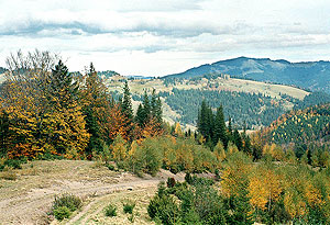
From everywhere is seen the mysterious, attracting wall of the mountains on the west and the southwest. These are the chains of the Pokytskykh Carpathians that occupy the largest part of the territory of the district. They stretch out from parallel ridges from the northwest to the southeast. The first row that rises above the wavy foothills consists of such chains. Between the rivers Lyuchkoyu and Pistynkoyu there is Lebedyn (805 m. o. s. l.) in the suburbs of Yabluniv, Utoropiv, Sheshoriv. Between the rivers Pistynkoyu and Rybnytseyu, in the suburbs of Pistynya, Kosova, Horoda — there is Kamenystyi mountain (734 m. o. s. l.), with offsets Klyfa (620 m. o. s. l.) over Pistyn and Stizhky (591 m. o. s. l.) over Kosiv.

Between the rivers Rybnytseyu and Cheremoshem there is Khomynskyi (879 m. o. s. l.) and over Kosiv there is the mountain Mykhalkiv (812 m. o. s. l.) and the chain Holytsya (nearly 600 m. o. s. l.). Near the foot of this chain and on it’s slopes are situated Kosiv, Babyn, Stari Kuty, Malyi Rozhen and Cherhanivka.
These mountain chains are rather high covered mainly with mixed forests with the predominance of beech tree and hornbeam. The vegetation gives a quality of charming beauty. In spring they are tender emerald, in summer thick green, and in autumn touches of gold and red and in winter it is grey. That’s why they are always attractive.
After the first chain, further to the west and the southwest, stretches the other row of chains: Karmatura in the suburb of Sheshoriv, Brusnyi (944 m. o. s. l.), between Prokuravoyu and Sokolivkoyu there is Sokilskyi (939 m. o. s. l.) and between Sokolivkoyu, Tyudovom and Velykym Rizhnom. After them stretch the chains Syhlin (858 m. o. s. l.) between Prokuravoyu and Kosmachem, Bukovets Brusturivskyi (969 m. o. s. l.), Bukovets Ritskyi (1059 m. o. s. l.), Ploskyi (914 m. o. s. l.), Maksymets (985 m. o. s. l.), the two last between Yavorovom and Velykym Rizhnom. These tops are mainly covered with spacious meadowlands and pastures, tsarynkamy, on which are situated either single or in groups, Hutsul settlements. Mountain streams run through deep ravines and are overgrown with fir trees.
Here and there are unusual picturesque maple and birch groves.
On the border between the Kosivskym, Nadvirnyanskym and Verkhovynskymy districts tower the highest waves of this still mountain sea: the Rokyta chains (1,110) in the suburbs of Bani-Berezova and Luychok, Lysyna Kosmatska (1,465), Hrehit (1,471) over Kosmach and Shepit, Ihrets with the top Chornyi Hrun (1,387) over Snidavkoyu, and Yavorovom, Pysanyi Kamin (1,322) on the territory of the Verkhovynskoho district. All chains have numerous apophasis much lower than the main chains.
Kosiv’s mountains are very well inhabited. The forests alternate with pastures, meadowlands, kitchen gardens and orchards. All the countryside is criss-crossed with paths and original pole fences. The roads are along the rivers. During the last years, the roads were connected with the centers of the villages.
The difference in elevation between the lowest part of the district and the highest part is over 1100 meters and this is in a distance of only some 30 km. This has contributed to a varied climate in a comparatively not very large territory. For example, spring in Kuty lowlands comes two-three weeks earlier than in Snidavtsi or Shepoti and, in contrast, the mountain villages see snow first.
The district, especially it’s mountainous part, has a lot of rivers and streams. Most of them have made the riverbeds across the chains, mainly from the west to the south; the smaller ones run through the Cloughs and gullies, between the chains, swiftly running, with crystal clean water, numerous rapids and waterfalls, murmuring rivers and streams that travel along the mountains between the picturesque shores are the marvelous beauty of our district. All of them have clearly mountain character: fast current, almost shallow during the most part of the year, large surges during flood-times after long rainfalls and torrents, not seldom destroyed selyovi phenomena.
The longest rivers, that run through the territory of the district, beginning from the west, are the Lutchka, Pistynka, Rybnytsya and Cheremosh.

To each river flow numerous smaller rivers — streams. So, only in the territory of Kosmach, into the Pistynka River, flow Stavnyk, Hrehitka, Tikach, Surupatul, Zhvyhr and Bahnyenka. The Brusturku River feeds the streams Brusnyenskyi, Serednyenskyi, Vyzhnyenskyi, Pidbrusnyenskyi and Pidkucherskyi. There are hundreds of streams and currents in the territory of the district.
No one has counted them all, recorded their names (often unquessed and mysterious), measured their length or speed of the current, and the rate of flow has not been defined. So there is a very interesting and important work for the students of local law.
The character of verdure of the Kosivskoho regional landscape park is influenced by the elevation above sea level. The forests cover 44,448 hectares, shrubberies — 2,351 hectares. In the lowest part of the district in the suburbs of the villages Tracha, Khimchyna, Kobak and Starykh Kut, are groves of deciduous trees.
The foothills cover the chains with beech and hornbeams forests with a mixture of fir-trees. The slopes of higher chains of Ihretsya, Hrehota and Lysyny Kosmatskoji are covered with fir-tree forests that begin at elevations not lower than 450–600 m.
Each sort of the forest has it’s unique beauty. In the beech forest the great high holes remind us of the greatness and powerfulness of nature. The feet lie under the thick carpet of the last year’s leaves.
The sun’s beams, penetrating through the top of the trees and reflecting from the silver boles, have a special tint. In spring and at the beginning of summer, the sounds of birds singing can be heard from beech and all leafy forests.
In contrast, in the fir-woods, rules solemn stillness-always. The wind blowing through the tops of the temple — like fir trees is the only sound. The air is filled with the healthy smell of fir-needles.
Differing in beauty are the remains of the maple groves that are on the vastness of the village that received from them their name Yavoriv. There is a lot of light, the sun, breathes in them lightly.
Circling the lower forest and the outskirts of the forests are numerous shrubbery plants — hazel-wood whitethorn snow-ball-tree, buckthorn, elder tree, and spurge olive. Grassy forest plants are also very rich. In beech forests bracken are often met madder aromatic ragweed grove, majivka double leaf, zubnutsya bulbysta, cowslip of Hellera, kremena white, tyrlych and over the streams there are Kremyanyk and others.

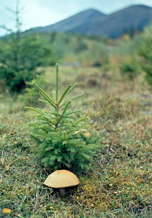
Typically in the fir forests are brackens, bilberry, and dewberry. The forests of the park are rich on mushrooms and edible boletus scaber.

