- About Ukraine
- Hutsuliya
- Hutsulshchyna
- History and Borders
- The Name and Origin
- Geography and Climate
- The Hutsuls
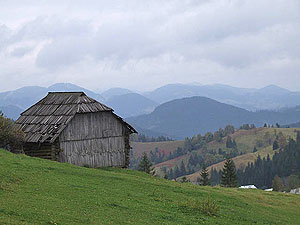
- Prycarpattia is my Motherland
- Nature and environmental protection
- Kosivshchyna
- Kosiv
- Yavoriv
- Kosmach
- Kuty
- Yabluniv
- Rozhniv
- Rest and Tourism
- Photograph Album
- Library
- Feed
- Store
Here in the Hutsul’s mountains, as anywhere else, one can hear the sound of talking — aching to draw strength and belief in the future. Here, in green-silver waters of lakes and rivers you may bathe and clean, not only the body, but also the soul, as the Carpathian sun warms it. Arriving on the top of Hoverla, to see God and to hear His kindness and tender voice — the voice of the creator of the Hutsuls’ mountains.
I. Franko, L. Ukrajinka, M. Dragomanov, M. Pavlyk, M. Hrushevskyi, A. Krushelnytskyi, V. Stefanyk, H. Khotkevych and many other famous Ukrainian writers drew strength from Hutsulshchyni. But not only they — Hutsulshchyna captured the hearts of famous Polish writers such as Stanislav Vintsenz, J. Kozhenyovskyi, Hrehorovych, Turchynskyi, Austrian Sakhera-Mazukha, K. Frantsoza, English M. Dovi and J. Konrad, Switherland Haus Zbindena and thousands of priests, ethnographers, scientists, teachers, musicians and simply people who were not indifferent to Hutsulshchyna.
Among those who studied it were V. Shukhevych, V. Hnatyuk, O. Makovei, F. Vovk, Australian Hake, German R. Kayndl and others.
An international commission was formed to study the culture of the inhabitants of the Carpathians resulting in printing a collection of scientific volumes and organization and implantation of international conferences and seminars.
So, where is Hutsulshchyna? Where are it’s borders? Even today, there is not one opinion. Mykhailo Lomatskyi wrote about it:
Hutsulshchyna is the Eastern Carpathians, Verkhovyna, Beskyd Green or so called Lisystym — covered with leafy trees — maples, beeches and alders (trees) and higher up the fir-trees and after them Zhereb…
Our Hutsulshchyna is the highest part of the eastern Carpathians; on one side of the rapid running rivers of Cheremosha and Pruta are the districts: Kosivskyi, Nadvirnyanskyi and very long ago Pechenihunskyi — on the other side, on Bukovyni, are the districts of Vizhnytskyi and Storozhynetskyi along Radivtsi and Kimpolunhy, and on Zakarpatti wide-spread forest areas over two rivers the Chornoyu and the Biloyu Tysamy, so called Maramorashchyna…
The highest chain, in the Hutsuls’ Carpathians, is Chornohora with the “queen” of the mountain tops Hoverla, the “king” Pip Ivan, and sleepy Petro.
It is considered that Volodymyr Hnatyuk gave the most complete definition, of the Hutsul ethnographical group:
Hutsuls inhabit the Carpathians in the Chornohory District. Their homes are scattered on both sides of Carpathians and reside in different countries. Of, course, their homes are stretched along the river valleys and streams.
In Halychyna they begin in Nadvirnyanskoji Bystrytsi to Pasichna and are along the river valleys Prut to Delyatyn, on the streams of the rivers Biloho and Chornoho Cheremosha, to Vyzhnytsi, along the river valleys Rybnytsi to Kosiv and the Pistynky River to Pistyn.
In Bukovyni the Hutsuls’ villages are situated along the river valley Putylivka, that runs into the Cheremosh and the upper streams of the Suchavy and Fryasy Rivers.
In Maramorashchyni the Hutsuls’ villages are stretched along the rivers Mokryanky, Teresulky, Shopurky, Kyjevy, Chornoji and Biloji Tysy. From Sycha, the border goes along the stream Brodynoyu.
Romanians lived on the right and on the left side — Hutsuls. There is narrower majority of Hutsuls upstream to Russian Moldovytsi over Bryaznu, Zolotu Bystrytsyu over Kirlibaby and the river Seretu, but here are fewer of them.
In 1987, summarizing collected materials, the authors considered that as of the end of the 19th and at the beginning of the 20th centuries, it is possible to trace a boundary line around the territory inhabited by Hutsuls. The western boundary, with Boikamy, was on the river Limnytsi and further in Zakarpatski, at the headwaters of the Teresvy and Berestyanka rivers, and in the valley of the Maloji Shopurku River to it’s confluence with Tysa. In the south, this line goes to the state border. In the north, northeast from the Limnytsi River the boundary crosses the Bustrytsyu Solotvynsku and Nadvirnyansku Rivers, captures the village of Pasichna, goes further to Delyatyn, Yabluniv, Kosiv, Vyzhnytsyu, Berehomet, Krasnojilsk and on to the border with Romania.
According to the administrative division, the territory encompasses the southern districts of Nadvirnyanskoho and Kosivskoho and the entire Verkhovynskyi districts of Ivano-Frankivsk oblast and also the southern part of Vizhnytskoho district and the Putylskyi district of Chernivetskoji oblasti and, also, the Rakhivskyi district of Zakarpatskoji oblasti.
Even a passing glance at this definition of borders of Hutsulshchna verifies it’s incompleteness, because there is not a single Romanian Hutsul settlement included in Maramorashchyny or Suchavshchyny on the right bank Pryprutskykh villages of Kolomyishchyny.
The border delineation of Hutsulshcha does not provide an opportunity to exactly define the number of towns and villages in the ethnographic territory and the number of inhabitants, namely — Ukrainian Hutsuls.
Volodymyr Shukhevych, for example, in his work «Hutsulshchyna» confirms, that in 1880 there were 54,634 Hutsuls, in 1890 — 63,265 people. Practically at the same time Yakiv Holovatskyi, 1872–1874, counted 68 villages in Halychyni, on Bukovyni — 20, on Zakarpatti — 21 Hutsul villages with 107,610 inhabitants. Lately, once more, there were censuses taken in different territories of Hutsulshchna and statistical attempts to generalize, but there is no clear picture of the whole ethnographic territory.
So, the scientific explorers, V. Hnatyk, Y. Holovatsky, V. Kybijovych, I. Senkiv, Falkovskyi, B. Shukhevych and others marked the territorial borders of Hutsulshchyna differently. Even now, in modern literature, there are inexact designations.
D. Vatamanyuk in his article «Administrative-Territorial Order of Hutsulshchyna» writes:
Hutsuls inhabit Ivano-Frankivsk, the whole Verkhovyna district, and the territory of the town of Yaremche, the whole Kosiv district, half of Nadvirnyanska and some villages on the right side of Pruta of the Kolomyya districts on Bukovyni, the whole Putylskyi district and the largest part of Vizhnytskoho; in Zakarpatti, also, Rakhivskyi district. There are more than 40,000 Hutsuls living in Romania in 25 mountainous settlements (M. Domashevskyi. The history of Hutsulshchyna. — Lviv. Lohos, 2001. — p. 528).
How to define a half the larger or the smaller part is unknown. However, it is easier to prove, that it is impossible to determine the exact ethnographical boarders than to try to define them.